
Energy Documentation
Arch Aerial LLC is a commercial UAS operator that provides end-to-end drone inspection services to pipeline operators, utilities, and municipalities. Utilizing the latest in drone technology and harnessing the power of large scale data capture and delivery, Arch Aerial LLC is a leader in the implementation and operation of UAS (drone) technology for the purposes of pre and post construction documentation, and disaster surveillance for midstream energy and utility companies. Through better data and less expensive patrol services, Arch Aerial LLC is changing the way midstream operators think about operations and maintenance of critical infrastructure.
Pipeline Aerial Videos
Arch Aerial provides midstream operators or midstream construction firms with high resolution aerial linear videos. Construction firms use Arch Aerial's imagery for pre-construction, mid-construction and post-construction. Midstream operators utilize Arch Aerial's video to gain an unique perspective over their assets and also to visualize the surrounding areas.
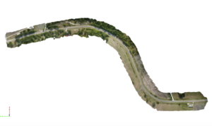
Pipeline Mapping
When it comes to major capital projects, liability becomes a priority. Through the use of Arch Aerial LLC drone services, midstream operators and utilities can capture pre and post construction documentation to collect proof of the state of the right of way, access roads, or nearby municipal roads to avoid costly remediation expenses.
AALLC_MidstreamConstruction from Arch Aerial on Vimeo.
Baseline Documentation of Pipelines
Arch Aerial LLC offers baseline pipeline mapping packages for pipeline constructors and operators alike. Get a snapshot of your right of way on an annual or bi-annual basis from your desktop rather than putting the truck in four wheel drive.
Pre & Post Construction Documentation
Arch Aerial LLC helps midstream operators minimize liability by deploying and capturing pre and post construction documentation on capital projects.
Disaster Response and Monitoring
Arch Aerial LLC offers rapid-response mapping after disasters so that risk and damage to assets can be calculated rapidly for quick reinstatement of services.